

Navigate PTC App: The Best Official Tool for Finding Peachtree City's Cart Paths
If you're moving to Peachtree City, GA, there's a good chance someone has already told you about the golf carts.
But there's something they may not have explained:
The hardest part isn't owning the golf cart. It's learning where all the paths go.
Peachtree City has more than 100 miles of shared-use paths connecting neighborhoods, schools, shopping centers, parks, recreation facilities, lakes, medical offices, restaurants, and other destinations throughout the city.
For longtime residents, navigating the system can become second nature.
For newcomers?
It can feel like learning an entirely new transportation network.
That's where the Navigate PTC app comes in.
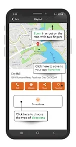
Developed by the City of Peachtree City, Navigate PTC is the city's official path-navigation app and is designed specifically to help residents and visitors use the community's extensive multi-use path system.
If you're searching for Peachtree City GA homes for sale, learning how the app works can actually help you understand one of the biggest lifestyle advantages of living here.
Here's what you need to know about Navigate PTC and why it belongs on your phone if you're planning to explore Peachtree City by golf cart.
What Is Navigate PTC?
Navigate PTC is an official mobile navigation application created by the City of Peachtree City.
Its primary purpose is to help people navigate the city's extensive shared-use path network.
The app supports multiple transportation modes, including:
Golf cart
Walking
Bicycle
It provides navigation assistance for getting from one destination to another using Peachtree City's path system.
That distinction is important.
Navigate PTC isn't simply another general-purpose map application.
It was created specifically around the unique transportation system that makes Peachtree City different from almost every other Atlanta suburb.
Why Peachtree City's Cart Paths Can Be Confusing
If you've never lived here, it's easy to look at a map and assume the paths are simply sidewalks.
They're not.
Peachtree City's shared-use path system functions as a major alternative transportation network.
The city describes its 100+ mile system as connecting:
Neighborhoods
Retail shopping centers
Schools
Places of worship
Office parks
Medical parks
Recreation centers
Lakes
That means the paths aren't just for weekend bike rides.
They can become part of your everyday transportation.
You might use a cart path to:
Take your kids to school
Go to dinner
Visit a friend
Pick up groceries
Reach a park
Get to a shopping center
Ride to a community event
The challenge is figuring out which path gets you there.
That's exactly where Navigate PTC can help.
Navigate PTC Turn-by-Turn Navigation
One of the app's primary features is navigation assistance.
According to the current official app listing, Navigate PTC provides turn-by-turn directions to destinations along the path system.
For a new resident, this can be a huge advantage.
Instead of staring at a static path map and trying to figure out:
"Do I take this path or that one?"
you can use the app to help guide your route.
This is particularly useful when you're exploring a neighborhood you've never visited before.
Choose Your Transportation Mode
Navigate PTC offers different modes for different types of users.
You can navigate using:
Golf Cart Mode
This is probably the feature most newcomers will use.
Golf cart mode is designed around the city's path network and makes it easier to plan trips without relying exclusively on traditional roads.
Walking Mode
Planning an evening walk?
The app can help you navigate the path network on foot.
Bicycle Mode
Cyclists can also use the application to explore Peachtree City's extensive shared-use paths.
This multi-mode functionality makes Navigate PTC useful even if you don't own a golf cart.
Why Golf Cart Mode Matters to Homebuyers
For someone researching Peachtree City GA homes for sale, golf cart accessibility can be an important part of the homebuying decision.
Imagine you're comparing two houses.
House A:
Great floor plan
Nice yard
Good price
Limited path access
House B:
Similar floor plan
Similar price
Direct or convenient access to the path system
Those homes may provide very different lifestyles.
With easy path access, you may be able to reach:
Schools
Shopping
Restaurants
Parks
Recreation
Community events
without getting into your car.
That is one of the features that makes living in Peachtree City GA so distinctive.
Use Navigate PTC Before You Buy a Home
Here's a tip for homebuyers:
Don't wait until after closing to learn the cart paths.
Use the app while you're house hunting.
When you find a home you like, open Navigate PTC and investigate the surrounding path network.
Ask:
Where does the nearest path begin?
Can I reach a nearby shopping center?
Can I reach a park?
Can my children get to school by path?
Can I ride to restaurants?
Is there a convenient route to Lake Peachtree?
How connected is this neighborhood to the rest of Peachtree City?
This gives you a much better understanding of the lifestyle you'll actually be buying.
Navigate PTC Can Help You Discover Local Businesses
The app isn't limited to navigation.
The current official app description says Navigate PTC also helps users discover shopping and dining destinations along the path system.
That's useful for both visitors and new residents.
Instead of thinking:
"Where can we ride tonight?"
you can start thinking:
"Where can we ride to tonight?"
That difference is a big part of the Peachtree City experience.
Find Community Events
Another useful feature is access to upcoming events and city information.
Navigate PTC's current feature list includes:
Upcoming events
City alerts
News and updates
Shopping
Dining
Community information
That makes it more than just a GPS tool.
For newcomers, this can be a convenient way to start becoming familiar with the community.
Share Your Location
Another feature listed by the City is real-time location sharing.
This can be useful when:
Riding with friends
Meeting family
Exploring unfamiliar paths
Letting someone know where you are
Coordinating group rides
If you're new to the city and still learning the path network, location sharing can add another layer of convenience.
Report Path Problems
Peachtree City's path system is a major piece of local infrastructure.
Navigate PTC also allows users to report problems or concerns they encounter around the city or on the paths.
That could make the app useful not only for getting somewhere but also for helping the city identify issues that affect residents and visitors.
If you encounter a problem, use the appropriate city reporting tools and follow current instructions within the app.
Cart Registration Is Also Linked Through the App
If you're buying a golf cart after moving to Peachtree City, Navigate PTC can also make the process more convenient by providing access to cart registration and renewal resources.
The city's current requirements are worth understanding before you purchase.
For 2026, Peachtree City lists resident motorized-cart renewals at $45 for the 2026–2028 three-year period, while non-residents pay a $15 annual registration plus a $235 annual path-user fee.
The city also states that new carts must be registered within 10 days of purchase.
That means Navigate PTC can become useful before and after you buy your cart.
Don't Confuse Navigate PTC With Older Third-Party Apps
If you've searched the App Store for Peachtree City cart-path maps, you may encounter other applications.
One older app called Peachtree City Cart Paths is still listed, but its own App Store description explicitly says that it is not affiliated with the City of Peachtree City and that its features are not identical to the city's official map.
That's an important distinction.
If you're looking for the official city-supported path-navigation resource, Navigate PTC is the one to start with.
There are also newer third-party golf-cart navigation applications entering the market. For example, Cruze Cart currently markets golf-cart navigation specifically for Peachtree City and offers features such as turn-by-turn navigation and offline maps.
Those alternatives may be worth exploring, but they shouldn't be confused with the city's official Navigate PTC application.
Is Navigate PTC Actually the "Best" Cart Path App?
Here's the honest answer:
It's the best official starting point.
That's different from saying it's the only app you should ever use.
The current Google Play listing shows a 3.8-star rating from 32 reviews, while Apple's U.S. App Store listing currently shows a 3.0 rating from 18 ratings.
Some historical reviews have reported navigation or stability problems, while the City has responded that updates were released to address certain issues.
So, if you're a new resident, the smartest approach is:
Start with Navigate PTC.
Learn the official path system.
Keep the city's official path map available.
And if you find that another navigation app works better for your particular phone or riding style, you can use it as a supplemental tool.
Always Keep the Official Path Map Available
Even if you're using an app, don't completely forget about the city's official maps.
Peachtree City maintains an interactive GIS-based path map and publishes information about the shared-use path system.
The city's GIS department maintains mapping layers that include:
Cart path locations
Street centerlines
Addressing
Zoning
Land use
Stormwater infrastructure
That makes the official GIS resources useful when you're researching a neighborhood—not just planning a Saturday ride.
Navigate PTC for New Residents
If you've just moved to Peachtree City, here's a simple way to learn the city.
Week One: Learn Your Neighborhood
Use the app to identify:
Your nearest path entrance
Nearby parks
Nearby shopping
Schools
Restaurants
Week Two: Explore Your Village
Ride farther out and discover how your neighborhood connects to the rest of the city.
Week Three: Run an Errand by Cart
Try riding to:
Coffee
Lunch
Shopping
The grocery store
Week Four: Take a Scenic Ride
Forget the errands.
Just explore.
That's when you'll begin to understand why so many residents love Peachtree City's golf-cart lifestyle.
A Great Tool for People Moving From Out of State
If you're relocating from another state, Peachtree City's path system can seem unusual at first.
In most suburbs, your transportation map revolves around:
Interstate highways
Major roads
Parking lots
Traffic lights
In Peachtree City, you have another layer:
The cart-path map.
That's one reason Navigate PTC can be particularly useful for relocation buyers.
Before you even move, you can use the app and official city resources to start understanding how different neighborhoods connect.
Use the App When Comparing Peachtree City Neighborhoods
One of the smartest things a buyer can do is compare neighborhoods based on path connectivity, not just home price.
For example, when evaluating communities such as:
Braelinn
Kedron
Planterra Ridge
Aberdeen
Glenloch
Wilksmoor Village
Smokerise
look at more than the homes.
Look at the map.
How easy is it to get from the neighborhood to the places you actually visit?
That could include:
Schools
Shopping
Restaurants
Parks
Recreation
Medical offices
Work
The path network can turn a location that looks ordinary on a traditional road map into an exceptionally convenient place to live.
Why Cart-Path Access Can Matter to Home Values
No single amenity guarantees appreciation.
But Peachtree City's path system is a major lifestyle feature.
The city itself describes the 100+ mile network as a defining feature of Peachtree City, connecting neighborhoods with retail, schools, medical and office parks, recreation centers, and lakes.
That connectivity can matter to buyers.
When people search for:
best neighborhoods in Peachtree City GA
Peachtree City GA homes near golf cart paths
best areas to live in Peachtree City for families
Peachtree City GA homes for sale
moving to Peachtree City GA
path access is often part of the lifestyle equation.
A neighborhood that allows you to use the cart system for everyday activities can offer something difficult to duplicate elsewhere.
Safety and Path Etiquette Still Matter
Navigate PTC can help you find the route.
It doesn't replace good judgment.
Remember that Peachtree City's shared-use paths are used by multiple types of travelers, including:
Golf carts
Cyclists
Pedestrians
Runners
Follow current city rules and pay attention to:
Speed
Visibility
Intersections
Path users
Posted signs
Construction
Detours
The City maintains a dedicated page for path rules and current updates.
And because path conditions can change, check current city detour and maintenance information before longer rides.
What Makes Navigate PTC Different From Google Maps?
Google Maps is excellent for traditional roads.
But Peachtree City is not a traditional transportation environment.
The city has a separate shared-use network that deserves its own navigation strategy.
Navigate PTC is specifically designed around that network and offers dedicated golf-cart, walking, and bicycle modes.
That makes it particularly useful for:
New residents
Golf-cart owners
Families
Cyclists
Walkers
Visitors
Homebuyers exploring neighborhoods
You aren't simply trying to find a street.
You're trying to find the path.
And that's a different navigation problem.
A Simple Navigate PTC Test for Homebuyers
Here's a great strategy if you're touring homes in Peachtree City.
Pick a property you're considering.
Then test three routes:
Route One: Home → School
How easy is the path connection?
Route Two: Home → Shopping
Can you reach a grocery store or shopping center without using major roads?
Route Three: Home → Dinner
Can you ride to a restaurant or entertainment destination?
If the answer is yes to all three, you've learned something important about the home's location.
You're not just buying a house.
You're buying access to a lifestyle.
Frequently Asked Questions About Navigate PTC
Is Navigate PTC the official Peachtree City golf-cart app?
Yes. Navigate PTC is developed by the City of Peachtree City and is promoted by the city as its official path-navigation app.
Is Navigate PTC free?
Yes. The current Apple App Store and Google Play listings show the app as free.
Can I use Navigate PTC for walking and biking?
Yes. The app offers golf-cart, walking, and bicycle modes.
Does Navigate PTC provide turn-by-turn directions?
Yes. Turn-by-turn path navigation is one of its primary advertised features.
Can Navigate PTC help me find restaurants and shopping?
Yes. The official app listing includes shopping and dining discovery along the path system.
Does Peachtree City really have more than 100 miles of cart paths?
Yes. The City of Peachtree City currently describes its shared-use path system as a 100+ mile network.
Should I use Navigate PTC instead of Google Maps?
For ordinary driving, Google Maps and similar road-navigation apps remain useful. For understanding and navigating Peachtree City's dedicated shared-use path system, Navigate PTC is the official city-specific tool and is the logical place to start.
Is Navigate PTC perfect?
No app is perfect. Current app-store ratings are mixed, and users have reported navigation issues in past reviews. The City has also responded to some reviews by noting updates intended to address reported problems.
For important trips, it's smart to understand the route before leaving and keep the official city path map available as a backup.
Final Thoughts
The Navigate PTC app is more than just another navigation application.
For people who understand Peachtree City, it represents something much bigger:
A map to a different way of living.
The city's 100+ miles of shared-use paths connect neighborhoods with schools, shopping, restaurants, recreation, lakes, offices, and medical facilities.
Navigate PTC helps newcomers understand how all those pieces fit together.
If you're visiting Peachtree City, download it before you start exploring.
If you're moving here, use it while you're house hunting.
And if you're already a resident, keep it handy when you're ready to discover a new route.
Because one of the biggest advantages of living in Peachtree City, GA isn't simply having a golf cart.
It's knowing where that golf cart can take you.
Thinking About Moving to Peachtree City, GA?
If you're searching for Peachtree City GA homes for sale, don't just compare houses.
Compare the path network around them.
The Tim Stout Group with eXp Realty can help you evaluate neighborhoods based on:
Golf-cart path access
Schools
Shopping
Restaurants
Parks
Lakes
HOA communities
Commute times
Home prices
New construction
Current Peachtree City real estate market trends
Whether you're looking for a home in Braelinn, Kedron, Planterra Ridge, Aberdeen, Glenloch, Wilksmoor Village, Smokerise, or another Peachtree City community, we'll help you understand not just the home—but the lifestyle surrounding it.
When you need anything real estate related in Peachtree City, GA, trust the local real estate experts at the Tim Stout Group with eXp Realty.
We proudly serve buyers and sellers throughout Peachtree City, Newnan, Senoia, and surrounding Fayette and Coweta County communities.
