

Peachtree City Cart Path Map: A Neighborhood-by-Neighborhood Guide
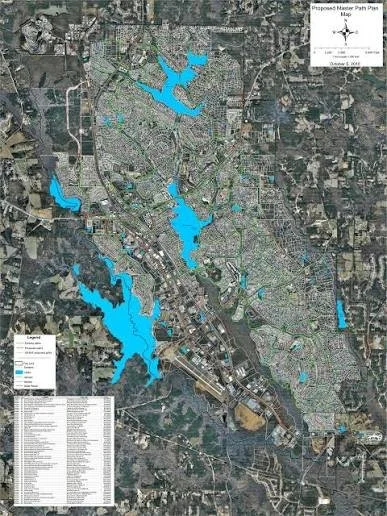
If you're searching for Peachtree City GA homes for sale, there's one feature you need to understand before choosing a neighborhood:
The cart path system.
Peachtree City isn't simply a suburban community that happens to have some recreational trails.
The city's 100+ mile shared-use path network is an important part of how residents move around the community. The paths connect neighborhoods with shopping centers, schools, parks, recreation facilities, medical offices, and lakes. They're used by pedestrians, cyclists, and permitted motorized carts. (peachtree-city.org)
That's why a home that looks perfect on a traditional street map may not necessarily be the best home for someone who wants the full Peachtree City golf-cart lifestyle.
The real question is:
Where does the path go from the house?
Can you reach a shopping center?
Can your kids get to school?
Can you ride to a restaurant?
Can you connect to another village?
Can you reach a lake or park without getting on a major road?
This neighborhood-by-neighborhood guide will help you understand the Peachtree City cart path map and how to use it when searching for your next home.
Important: The official City of Peachtree City GIS map is the best source for checking the exact path connection to a specific property. Path routes, access points, rules, and construction can change, so always verify the current map before purchasing a home.
Start With the Official Peachtree City Cart Path Map
Before looking at individual neighborhoods, understand how the system works.
The City of Peachtree City maintains an official interactive GIS path map along with current and historical path-system maps. (peachtree-city.org)
The city describes the network as more than 100 miles of shared-use paths connecting:
Residential neighborhoods
Shopping centers
Schools
Parks
Recreation centers
Medical and office areas
Lakes
Community destinations
Visit Peachtree City also describes the paths as a secondary means of access to almost any destination within city limits, with many businesses providing designated golf-cart parking. (visitpeachtreecity.com)
That's a major distinction.
The paths aren't simply something you use for a Saturday afternoon ride.
For many residents, they're part of everyday transportation.
How to Read the Peachtree City Cart Path Map
When you're looking at a home for sale, don't just search for a colored path line nearby.
Look at the connection.
There is a big difference between:
A home near a path
and
A home with convenient access to a path that connects to your everyday destinations.
When evaluating a property, trace the route to:
The nearest shopping center
Your children's school
Your favorite restaurant
A grocery store
A nearby park
The nearest village center
Lake Peachtree or another recreation destination
Your workplace, if practical
The official map is especially useful because the Peachtree City path system includes crossings, bridges, wooded sections, tunnels, and connections that aren't obvious from a normal road map.
Braelinn: Classic Peachtree City Cart Path Living
Braelinn is one of the first neighborhoods many buyers encounter when researching Peachtree City GA homes for sale.
The area is known for:
Established neighborhoods
Mature landscaping
Family-friendly surroundings
Shopping access
Recreation
Extensive path connectivity
Braelinn's paths are particularly attractive to buyers who want the traditional Peachtree City experience.
A ride through the area can take you through wooded corridors, residential streets, parks, and lake areas.
The broader path network also connects Braelinn to other parts of the city.
Who Should Consider Braelinn?
Braelinn may appeal to buyers who want:
An established neighborhood
Mature trees
Convenient shopping
Golf-cart access
Family-oriented living
Easy access to recreational amenities
If you're comparing Braelinn homes for sale, don't just compare the houses.
Compare their individual path connections.
Two homes in the same general area can provide very different golf-cart experiences.
Kedron: Convenient for Commuters and Families
Kedron sits toward the northern part of Peachtree City and is particularly interesting for buyers who prioritize both path access and regional commuting.
The area provides connections toward:
Shopping
Recreation
Schools
Highway 74
Highway 54
Northern Peachtree City
The path system is one of the reasons Kedron can offer a particularly convenient lifestyle.
You can potentially combine a golf-cart trip with:
Shopping
Dining
Recreation
School activities
Neighborhood visits
Why Buyers Watch Kedron
Kedron often attracts buyers searching for:
Family homes
Convenient commuting
Established neighborhoods
Path access
Shopping nearby
Recreation
If you're comparing Kedron homes for sale, check the path map before assuming a property has the connectivity you're looking for.
Glenloch: Central Access to the Path Network
Glenloch occupies a central position within Peachtree City and is an important area to examine when evaluating path connectivity.
One advantage of central locations is that you're often positioned to connect with multiple parts of the city.
Glenloch can provide access toward:
Lake Peachtree
Central recreation areas
Shopping
Other Peachtree City villages
Major path corridors
For buyers who want to use their golf cart for more than occasional recreation, central location can be valuable.
Glenloch May Appeal to:
Families
Professionals
Active residents
Golf-cart users
Buyers who want convenient access throughout the city
A map-based search is particularly helpful here because the exact path connection can vary by street and property.
Aberdeen: Southern Peachtree City Path Access
Aberdeen is another established Peachtree City village worth exploring.
The area is known for:
Residential neighborhoods
Larger homes in some sections
Mature surroundings
Access to recreation
Connection to the larger path network
Aberdeen can be appealing to buyers who want a quieter suburban environment while maintaining access to Peachtree City's unique transportation system.
For families considering Peachtree City GA homes for sale, Aberdeen is worth comparing with Braelinn, Glenloch, and other established villages.
Planterra Ridge: Golf, Paths, and Established Living
Planterra Ridge is particularly attractive to buyers interested in golf-oriented living.
The community combines:
Established homes
Golf course surroundings
Recreation
Mature landscaping
Path connectivity
For golfers, the connection between the residential community and nearby recreational amenities can be a major lifestyle benefit.
And for buyers who aren't golfers, the paths still provide opportunities to reach parks, shopping, and other parts of Peachtree City.
When Comparing Planterra Ridge Homes
Look at:
Golf course proximity
Path access
Lot location
Home age
HOA information
Shopping distance
School assignment
The path map should be part of that evaluation.
Wilksmoor Village: Newer Homes and Growing Connectivity
Wilksmoor Village represents a newer chapter in Peachtree City's development.
Buyers searching for Peachtree City GA new construction may want to pay particular attention to this area.
The community can appeal to people looking for:
Newer construction
Modern floor plans
Contemporary finishes
Growing neighborhood amenities
Family-friendly design
But when buying in a newer community, it's especially important to understand both the current and planned path connections.
Ask:
Where does the path connect today?
And:
What future connections are planned?
Don't assume a planned path is already open or that a future connection is guaranteed.
Smokerise and Other Established Communities
Peachtree City's path network also serves many smaller neighborhoods and established communities beyond the major village names.
When searching for a property in areas such as Smokerise, St. Andrews, The Peninsula, Kedron Hills, and other communities, the same rule applies:
Evaluate the actual path connection from the property.
The citywide network means that a smaller neighborhood can still provide excellent access to the larger system.
For buyers, this creates opportunities to search beyond the most recognizable neighborhood names.
Village Centers Matter When Reading the Map
One of the smartest ways to understand Peachtree City's path system is to think about village centers.
Peachtree City was designed around villages and neighborhood-serving commercial areas.
Official planning documents identify village areas including:
Aberdeen
Glenloch
Braelinn
Kedron
Wilksmoor
These areas are connected by residential neighborhoods, green space, commercial centers, and paths. (peachtree-city.org)
This matters because you aren't simply buying a house.
You're choosing which part of the city's interconnected lifestyle you want to plug into.
The Avenue Peachtree City and the Cart Path Network
For many residents, one of the most useful destinations to reach by golf cart is The Avenue Peachtree City.
The open-air shopping and dining center offers restaurants, retail, outdoor gathering areas, and green space.
Visit Peachtree City highlights the city's path system as a way to reach shopping and dining destinations without relying exclusively on a car. (visitpeachtreecity.com)
If The Avenue is somewhere you'll visit frequently, trace the route from potential homes before making an offer.
A five-minute difference on the map can become a meaningful lifestyle difference over hundreds of trips.
Lake Peachtree Connections
Lake Peachtree is another major destination buyers should consider when evaluating the cart path map.
The lake offers:
Walking
Running
Fishing
Scenic views
Water recreation
Outdoor gathering areas
The city's path system connects residential areas with lakes and recreational destinations, making lake access part of the broader Peachtree City lifestyle. (peachtree-city.org)
For buyers who love outdoor recreation, a home with convenient path access toward Lake Peachtree can be especially attractive.
Flat Creek Nature Area and the Path System
Peachtree City's outdoor lifestyle extends beyond residential neighborhoods.
The Flat Creek Nature Area is a roughly 500-acre natural area featuring wetlands and a boardwalk.
The path network and recreational system help connect residents with some of the city's natural areas.
For buyers who enjoy:
Bird watching
Walking
Photography
Wildlife
Nature
this can be another factor to consider when comparing neighborhoods.
The Fred and Cart Path Access
The Frederick Brown Jr. Amphitheater, commonly known as The Fred, is another major Peachtree City destination.
The open-air venue hosts concerts and community events.
For residents, being able to combine:
Golf cart ride + dinner + concert
is one of the lifestyle advantages that makes Peachtree City different from many suburbs.
When you're evaluating a home, check how easily the path system connects your neighborhood with entertainment destinations like The Fred.
Shopping, Restaurants, and Everyday Errands
The best cart-path location isn't necessarily the one closest to a lake.
For many homeowners, the most useful path connection is the one that makes everyday errands easier.
Consider mapping your potential rental or home to:
Grocery stores
Coffee shops
Restaurants
Pharmacies
Medical offices
Schools
Fitness centers
Shopping centers
Visit Peachtree City specifically promotes the path network as a secondary means of access to destinations throughout the city. (visitpeachtreecity.com)
That is why path access can become a genuine real estate consideration rather than simply a recreational feature.
The Best Way to Use the Cart Path Map When Buying a Home
Here's the process I recommend to buyers.
Step 1: Find the Property
Start with the exact address.
Don't search only by neighborhood name.
Step 2: Open the Official GIS Map
Use the City of Peachtree City's current interactive path map.
The city provides access to the current system map from its official Shared-Use Path System page. (peachtree-city.org)
Step 3: Find the Nearest Path
Look for the actual connection from the neighborhood.
Don't assume a path shown nearby connects directly to the street you're considering.
Step 4: Trace Your Destinations
Map the path to:
School
Grocery store
Restaurant
Shopping
Park
Lake
Workplace, where practical
Step 5: Test the Route in Real Life
This is one of the best pieces of advice for anyone buying in Peachtree City.
Ride it.
A route that looks easy on a digital map may feel different in person.
You may discover:
Hills
Road crossings
Bridges
Tunnels
Busy sections
Scenic wooded areas
Easier shortcuts
The real experience matters.
NavigatePTC: The Official App for Path Navigation
Peachtree City also promotes NavigatePTC, its official path-navigation app.
The city describes NavigatePTC as a tool for navigating the path network, and the app is designed specifically around Peachtree City's unique transportation system. (peachtree-city.org)
Depending on the current version, features include navigation and other city-service functions.
For anyone new to Peachtree City, it can be useful to have the official navigation tool available before exploring unfamiliar routes.
Cart Rules Matter, Too
A cart-path map is useful, but knowing the rules is just as important.
The city currently requires motorized carts to comply with its registration and operating requirements.
For 2026:
Resident three-year renewals total $45
Non-residents pay a $15 annual registration fee plus a $235 path-user fee
New carts must be registered within 10 days of purchase
Current decals have specific placement requirements
Low-speed vehicles have separate requirements
The city also publishes current path-use rules and safety information. (peachtree-city.org)
Rules can change, so check the city's official information before purchasing or operating a cart.
Why Path Access Can Affect Home Value
There's no formula guaranteeing that a house with better path access will appreciate more.
But lifestyle features can influence buyer demand.
Consider two otherwise similar homes.
Home A:
$575,000
10-minute drive to shopping
No convenient path access
Home B:
$585,000
Direct path access
Golf-cart connection to shopping
Convenient route to parks and restaurants
A buyer who specifically wants the Peachtree City lifestyle may prefer Home B.
That doesn't automatically make it a better investment.
But it illustrates why location within the path network can influence buyer preferences.
The Cart Path Map Is Also a Neighborhood Map
Here's an important way to think about it:
The Peachtree City cart path map is almost a second neighborhood map.
A traditional street map tells you:
Roads
Intersections
Highways
Commercial areas
The cart path map tells you:
How residents move locally
Which neighborhoods connect
Where you can ride
How parks connect
Which shopping areas are accessible
How the villages relate to one another
For someone moving to Peachtree City GA, that second map can be just as important as the first.
Which Peachtree City Neighborhood Is Best for Cart Path Access?
There isn't one universal answer.
Different buyers want different things.
Braelinn
Strong established neighborhood character and convenient path access.
Kedron
Excellent for buyers who prioritize northern access, schools, shopping, and commuting.
Glenloch
Central location can provide convenient access to multiple destinations.
Aberdeen
Established southern living with connections into the larger network.
Planterra Ridge
Strong option for buyers interested in golf-oriented living and established neighborhoods.
Wilksmoor Village
Interesting for buyers who want newer construction and a growing community.
The key isn't choosing a neighborhood simply because someone says it has "great cart access."
The key is finding the specific property with the specific path connection you need.
Frequently Asked Questions About the Peachtree City Cart Path Map
How many miles of cart paths does Peachtree City have?
Peachtree City has a network of 100+ miles of shared-use paths. (peachtree-city.org)
Is there an official Peachtree City cart path map?
Yes. The City of Peachtree City provides a current interactive GIS map and path-system information through its official website. (peachtree-city.org)
Does every home have direct cart path access?
No. Path access varies by property. Always check the exact address.
Can you use the paths to get to shopping?
Yes. The city and Visit Peachtree City describe the network as connecting neighborhoods to shopping, dining, schools, parks, recreation, and other destinations. (visitpeachtreecity.com)
Can you ride a golf cart from Peachtree City to Atlanta?
No. The system is designed for local transportation within Peachtree City and its connected destinations. It is not a route to Atlanta.
Are the paths only for golf carts?
No. They're shared-use paths for pedestrians, cyclists, and permitted motorized carts, among other authorized users. (peachtree-city.org)
Should I check path access before buying a home?
Absolutely. If the golf-cart lifestyle is important to you, path connectivity should be part of your home search.
Final Thoughts: Map the Path Before You Buy
When you're searching for Peachtree City GA homes for sale, it's easy to focus on the house.
The kitchen.
The bedrooms.
The backyard.
The garage.
The price.
But in Peachtree City, there's another feature you should always investigate:
The path.
Where does it go?
What can you reach?
Can you ride to dinner?
Can your kids reach school?
Can you get to the lake?
Can you reach a park?
Can you get to The Avenue?
Can you connect to another village?
Those answers can completely change how you experience your home.
The official Peachtree City map gives you the starting point, but the best way to understand the system is to combine the map with a real-world tour of the neighborhoods you're considering.
That's where local real estate knowledge becomes valuable.
Thinking About Moving to Peachtree City, GA?
If you're searching for Peachtree City GA homes for sale and the golf-cart lifestyle is one of the reasons you're considering the city, don't choose a home based on the house alone.
The Tim Stout Group with eXp Realty can help you compare:
Cart-path access
Peachtree City neighborhoods
Schools
Commute routes
Shopping and dining
Parks and recreation
HOA communities
New construction
Home prices
Current Peachtree City real estate market trends
Whether you're looking for a home in Braelinn, Kedron, Glenloch, Aberdeen, Planterra Ridge, Wilksmoor Village, or another Peachtree City community, we'll help you understand how the location fits the lifestyle you're looking for.
When you need anything real estate related in Peachtree City, GA, trust the local real estate experts serving Peachtree City and surrounding areas: the Tim Stout Group with eXp Realty.
Contact us today through our Peachtree City real estate team.
